Friday, April 24, 2015

Primrose Gardens


When assigned to photo-document the Keeling house, my team members and I have also been assigned to conduct researches on the Primrose Gardens which is in Belsize Park near Camden Town. It takes on entire urban block, consisting of 4 different but typical types of English urban housing styles.


On the side facing the England's Lane, which is the main street of this neighborhood, is a row of 2 to 3 small size houses with individual shops and restaurants. In term of the scales, the grocery stores are incomparable to the flagship stores on Oxford street and the restaurant can hold only 10 to 20 customers at most at a time: these individual small business are only meant to serve the surrounding neighborhoods, not for the entire district or larger ranges. By providing basic needs and entertainments for the very neighborhood they located, these stores function as a community center efficiently bond the surrounding households together. The plants in the middle, I think is multifunctional and important to this neighborhood. It separates the two directions of traffic flow; it provides public meeting space for the local residents; it provide visual barriers for families living on the upper floors in the town houses.
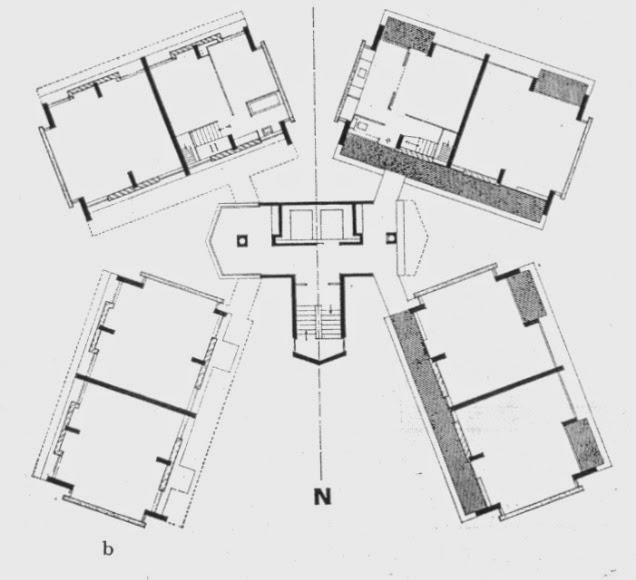
Primrose Gardens and the central long green stripe.


On the northeast side is a row of conventional town houses of the Victorian era. At the first glimpse, the front of all the town houses look identical. However, under the seemingly universal facade design, there are two to three different variations in the design. The brick patterns, the style of the pediment on the doors and windows tell the differences when coming and looking up close. Between the two row houses is a long stripe of greenery along with a series of public space hidden between trees and bushes. The landscape design reflects the "Garden City Movement" initiated in 1898 in London. On its opposite side, the Belsize Park side, is a completely different scene. The first thing to notice is the size of a parcel of land is much larger than that of the Primrose Gardens side's. The housing type also changes from repeated town houses into independent 3-storey villas. Through the "slots" between the villas and the turning corners of this blocks we are able to have a peek of the rather complicated yet interesting collisions of the backyards of the buildings on both sides.


Primrose Gardens show us the adaptation ability of the traditional English row houses. The residents of the neighborhood can change the layouts (both in plan and section) as well as the program of the row houses according to the actual context situations. From the basic division of the lands to the variations in programs and finally to the detailed design on the front facade as well as the turning corners of the blocks, the freedom of space comes from the simplicity of structures. From Primrose Gardens I can even see the composition of neighborhoods of the entire London.

Saturday, April 18, 2015

Keeling House and English Housing Modernism


The drawing of the Keeling House in London.


At the beginning of the semester, we visited the Keeling House as one of the housing research precedent cases. The 15-story, high-density residential tower is located in Bethnal Green, in east London. The building consists of 4 independent towers joined by the circulation core in the middle. In each tower, we can find not only one-floor flat units for a family of 2, but also two-story maisonette units which can provide enough living space for a family of 4 to 5 people. Built in 1957, this project has undergone two major design conversions to its exterior. In year 2001, a steel-framed front foyer was added to the entrance of the building. Following that in 2014, the concrete water tank on the top of the building was planned to converted into a penthouse with the approval of the landlord.
The new front foyer added in 2001.

The National Theatre by Denys Lasdun.
The residential tower is originally designed by Sir Denys Lasdun, the architect who also designed iconic public landmarks on South Bank like the National Theatre and the IBM headquarters. The use of cast concrete is one of the most significant characteristics of his architectural style. The Keeling House is also an example of Brutalist architecture in London.
The Keeling House, looking from the streets of Bethnal Green
On one hand, the nature of the material is able to provide a clear and artificial environment to the inhabitants secluded from the natural elements. The exposed entrance of the original design somehow creates a more clear boundary between the inside and outside world of the Keeling House. The precast concrete with minimalist decorations separates the outdoor weather with the interior, creating a sense of protection just like Denys Lasdun did with the National Theatre. On the other hand, this project is definitely, not a mere replica of the military bunker architecture during the World War II on French coast. Through specific architectural details, we can tell the intention to create social mixes within the elevated neighborhood: To begin with, the large windows installed both at the front and back of each flat increase engagements between life in the tower and the city landscape. The corridors on the same floor are positioned in an obtuse angle instead of the conventional parallel layout, to encourage communications and meetings between two towers.

Additionally, a shared plaza which can only be accessed by the residents of the Keeling House is distributed on every two stories, right at the center of the building along with the elevator core. However, these public space can not be accessed through the elevators: they are only connected to the stairs and doorways which can only be opened by the owners of the flats. On the "public" plazas, people can get a clear view of the city while meeting the rest of the members of the small neighborhood. It is the private "gardens" and adjacent corridor layout in the air that separates the Keeling House from the other conventional Modern collective housing projects in London.
The plaza shared by the residents in the air.
One interesting phenomenon I find about English Modern housing projects is that most of them are located in the eastern part of the city. Modern architecture and the collective-ness of urban life it represents were much favored by the government in the mid 20th century. Projects like the Keeling House and Robinhood Garden near Canary Wharf on the Isle of Dogs were designed to be used as social housing for citizens with low and intermediate level of social incomes. The modularized compact units are, sure enough, relatively affordable to the London residents, considering the high land prices in London (especially within Zone 1 and 2). However, one of the social goals of Modern architecture is to promote "social mixes" between different social classes in the city. The problem of the Keeling House is that when it was constructed, it failed to attract the attention of the wealthy class which were living in the suburbs and the west side of London. Therefore it may successfully create opportunities of socializing to the residents within the building, it failed to gain a variety of the social backgrounds of the residents in the first place. On the other end of the scale is the Barbican Center, which has been gentrified over the years and turned into a concrete "fortress" for the wealthy Londoners (apart from the public programs such as the theatre and cinemas). In general, most of the English modern housing projects are ideal but unrealistic design proposals by architects who wanted to redesign people's urban life in a metropolis.
Perspective drawing created by Alison + Peter Smithson for the Robin Hood Gardens.

Fortunately the situations has been changed in recent years. The Keeling House is once more cherished by people of various social backgrounds and now it is the home to many architects and designers in London.

Sunday, April 5, 2015

The "Picturesque" English suburb

In recent architectural survey field trip, I paid a visit to the Hampstead Heath of London. Since I am getting used to the "typical" city landscape of (central) London which is complicated mixture of glass, steel, brick and stone, the tranquility and "picturesque-ness" of the suburban view of London really surprised me. In this region, the architecture is no longer the absolute dominant elements in the images. Instead, large portions of the landscape is filled by the natural environment.

The nature adds dynamic elements to the architecture.

The suburbs of London is the experiment grounds to realize the ideas of the late 18th century and 19th century architects like William Kent, John Soane, artists like JMW Turner. The key concept is to "blend in " the architecture with the landscape. Taking the nature as a force to help improve the design of architecture.

The area of the front yard replaces the "bridges" over the basement floor of the town houses which are common in the city. When looking from the street side, the houses/villas are able to set back in the background. On one hand the landscape in the front yard provide a certain level of privacy to the residents. On the other hand, it is also an interesting way to imply the aesthetic tastes of the house owners. In the photo above, it seems like the owners want to replicate the classical British and French Royal gardens into their own lawns in front of the house.


The exterior of the church is rather a product from the era of the "battle of the styles". The roof of the nave of the church imply the style of the medieval time, Gothic architecture. The tower and dome in the transept reminds people of Wren's Baroque architecture in the late 17th century. the use of red bricks and ornaments on the front entrance resulted from the influence of the neoclassical architecture in the Victorian Era. 

The brick pattern detail on the public buildings represents the respect to the craftsmanship, emphasizing the handcraft motif at that time. The corner of the school building uses two different kinds of bricks and respective layout patterns. 

Saturday, April 4, 2015

One interesting moment in the streets of London - The boundaries


This is a street crossing on Clerkenwell Road in Saffron Hill near where I live in London.

The boundary lines of materialities in the city. For instance the North and South bank near London Bridge. On the South Bank, the representative architecture are the London City Hall designed by Foster+Partners, the Shard designed by Renzo Piano and the ... These buildings have exposed steel structure or glass cladding on the exterior.


Saturday, March 7, 2015

World above and below the ground - Canary Wharf


The master plan designed by SOM. turned the deserted wharf to a modern CBD, a second business center of London.

The population difference on the ground floor of Canary Wharf. People work in the offices in the towers. The shopping, catering happen underground. Necessary transportations happen on the ground floor such as the trains and highways. The leftovers space becomes landscapes and plazas. The civic plazas look like islands in the CBD districts, connected by underground walkways.

Site plan of Canary Wharf. (image source: SOM)

From the plan, the entire site is divided into clear rectangular grid. Several distinctive blocks, each with a public garden in the middle. There is no wide street on the site for the reason that the original wharf doesn't have enough area to accommodate circulation and transportation. The other reason is that most movement and activities of the office workers (as well as the residents) are designed to be hidden underground. There is another city underneath the ground floor. Above the ground the predominant program is offices of large, private corporations, on the basement levels almost all the buildings are connected. The entire Canary Wharf can be understood as a large mix use complex, only the first two to three common floors are buried under the ground.

In the past history, London has also gone through similar planning strategies of creating different city trading centers to compete each other. The de-centralization will bring prosperity to a new urban district.

Also, the utilization of the disused industrial zone has always been a popular topic in London as well as other developed European city. From specific industrial building conversion project such as the Tate Modern and the recent housing complex development around the Battersea Power station. The change of program in the regions of city bring about some very interesting phenomena. New programs introduced into the old area will also initiate potential development opportunities for its surrounding neighborhoods. The process of creation and demolition is accompanied in the development of a city.

The neutrality of the original plan and structure means industrial plants has more potential, to adapt diverse public program and social infrastructures in the future. In another word, they are more easily to be converted.

Saturday, February 28, 2015

The Steel and brick of the London south bank


@London South bank, Lambeth London

The most obvious, but also the most easy comment about the London south bank that one can give is "fragmented": The entire area can be interpreted as a "layered city":


The waterfront is the first layer. It can be considered as a giant "billboard" with assorted advertisement and ornaments, facing the historical, prosperous city center on the north side. Tourists, or non-residents are usually trapped in the great wall of entertainment and information. There are monumental icons of the entire city such as the London eye, entertaining center such as the Royal Festival Hall, and mixed-use shopping complex such as the OXO Building. For people in the City and the Westminster City, the media wall is somehow, connected to the north bank with the multiple bridges. The first row of buildings are the defensive wall of the city center, segregating the waterfront from the south bank. The Thames River is, to some extends, not separate buildings on the banks, but encouraging the connections between them. Also, it clear the view, provides a visual corridor for the people from each of the banks.

Hidden behind the wall of information and are the region which belongs to large private corporations. This area can be characterized as the "generic", or "grey" area with high level of privacy.

Through the few "slots" between the giant headquarters, people can have a glimpse of the real south bank behind.There is always conflict breaking out on the land of the waterfront of the south bank. The contradictions usually involves the residential housing blocks and financial, giant office buildings. In the past, due to the construction of the Waterloo Station on the south bank, housing projects with moderate and low density were built around the railway station. With the evolution of the London society, currently the territories of residences are gobbled up by trade and marketing business. In traditional residential neighborhoods,

The strange feeling walking on the streets of the south bank. The huge difference in scale between different buildings and programs.


What is the order between the bricks and steel on the south bank? The value of the land? Preservation of the history on the south bank? Architecture or revolution. Should we keep the existing housing project on the south bank?


Sunday, February 22, 2015

The Somerset House and the Temple Church


The Temple Church is on my top ten list of the destinations that I must pay a visit during my stay in London. Sure enough, I got the chance to have a glimpse when the professors of the design studio took us on a tour from the Brunswick Center to the North river bank at the beginning of the semester. I was interested in this particular church, oddly enough, due to Dan Brown's novel "The Da Vinci Code". The author depicts the Temple Church as the starting point where the modern London City is built from. However, if look at London from the top in the sky, we will discover that the city center (of the North bank) is St. Paul's Cathedral. Also, from the history we can conclude that even before 1666, the year of the Great Fire of London, the two centers of the city have been The Buckingham Palace and St. Paul's in the City: It has never been the Temple. Therefore I'm very curious to find out what is the actual conditions of this mysterious church in the contexts of the present day.


Unlike other major churches in London, the Temple Church is surrounded by parcels of private land that are densely packed with multistory residences and private offices.

Saturday, February 14, 2015

Squares in London

I. Paternester square next to St. Paul's Cathedral:


Before the square: 1960s Great London Council project. large office buildings built right next to the ancient church. The modernism thinking: completely ignorance of the context information. In scale, the office complex is nearly as big as the cathedral. Which means the former buildings on the site Formally, it didn't respond to the church. Visually, it decreased St. Paul's impact as the historical icon of the city center.

II. Hidden gardens in the city: Traditional English city gardens before Modernism was introduced. London was consisted of hundreds of small villages. Each has a religious and public gathering spot, like a parish church and the field. e.g Lincoln's Inn Field.

III. Waterfront green belt: south bank walkway:


Saturday, February 7, 2015

From Inigo Jones to Social Housing: Covent Garden


For most tourists, Covent Garden usually is not the first places to visit when touring in London.

Covent Garden is located in the junction area of the borough of Westminster and Camden, between the Westminster City and the City of London. Therefore, in the urban history of London, Covent Garden is a relatively younger region in the development history of London city.

In the mind of Inigo Jones, Covent Garden should be an idealized and improved British version of a typical Italian neighborhood: four rows of residential housings surround a central piazza with a church in the middle as the social gathering center.

The idea behind the planning of Covent Garden was to divide separate living communities for London citizens with social incomes. It was meant to be a gentrified neighborhood for the upper middle class. However, rather ironically, when two grocery market were introduced into the central piazza, along with the growth of population in London and the deterioration of the sanitation of the urban environment, wealthy families soon moved out of Covent Garden to the west side of the city and finally into the countryside.

It really came as a surprise to me when I got to know that the Odhams Walk is actually a housing project sits at the center of the dense commercial district. The Odhams Walks is a social housing project dates back to 1960s. It was designed by the Great London Council is as sociation with designer Donald Bull. It created a quite world of gardening, excluding all the noise and crowdedness of the outside world.

One interesting thing about the Council Housing projects is that they always focus on the collectiveness and compactness. They are trying to create a microscopic, scaled-down city within the boundaries of the construction site. Such projects (such as the Queen Elizabeth Hall, the Robin Hood Garden, etc.) share some common characteristics: Multiple layers and circulations, heavily exploited ground (multiple ground floors, many of which are hidden beneath the central plaza )

The housing project is constructed above a semi-underground carpark.


The floor plans at the entrance of the Odhams Walk.
The multiple layers of the Odhams Walks enable a diversity of circulations and also plenty of terraced spaces for outdoor gardens. The routes to the top floor were deliberately zigzagged so that the visitor (also the residents) will constantly moving between the interior and the exterior of the Odhams Walk. 


View of the inside of the Odhams Walk

The meandered and significantly different paths on different levels exaggerate the physical area of the project, residents and visitors have to walk constantly between the indoor and outdoor space, sometimes pass through one of the resident's font yard, sometimes